PART I
INTRODUCTION
Location of the area
The area investigated was a part of south east Harris between Rodel and Finsbay
Its extent is approximately 9.6 square kilometres (3.7 square miles).
Purpose, dates and procedure
This investigation was intended to be a general geological study of the area, based on field work carried out between June 22nd and July 18th 1972. The procedure generally adopted during field mapping was that of rapid traverse, using a compass and pacing to locate outcrops on Ordnance Survey 1:10,560 scale maps (numbers XXIII and XVIII). The more important outcrops were located by means of angular measurements, using the compass.
Owing to the short time available for field work, many parts of the area were not studied in as much detail as would have been desirable, and in some parts of the area only a rapid reconnaissance was undertaken. This was the case in the areas immediately to the north and west of the C79 road between Strath Leetein and Loch na Cachlaidh; the southern part of the Stron Ghaoithe headland; and the Rodelpark area.
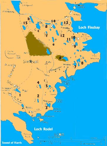
Some parts of the area, however, were investigated in greater detail than was normally the case. These included the Lingerbay - Bayhead - Ard Mor area; the St. Clement's Church area; and the area to the west and south west of Finsbay (figure 2).
In all cases dips of foliations and plunges of lineations were estimated by eye since the exposures in the area are generally much smoothed by glaciation and hence do not suit more accurate methods.
MAJOR GEOGRAPHICAL FEATURES
| |
Fig 2: principal geographic features of the area.
| Loch name | |
| 1. | Loch Ossigary |
| 2. | Loch an Dun |
| 3. | Loch Vallarip |
| 4. | Loch na Cachlaidh |
| 5. | Loch na h-Uamh |
| 6. | Loch na Criadlach |
| 7. | Loch na Buaile |
| 8. | Loch na Lurgann |
| 9. | Loch na h-Uidhe |
| 10. | Loch na Beiste |
| 11. | Loch a' Sgurr |
| 12. | Loch an Luig |
| 13. | Loch an Sgumain |
| 14. | Loch Aonais Mhic Fhionnlaidh |
| 15. | Loch Allityer |
(i) Physiography
Roneval, with its subsidiary ridges Sletteval and Stuigha, is the dominant physiographic feature of the area. It is the principal watershed of south east Harris and the Abhuinn Collam and many smaller streams rise on its slopes.
The principal stream system of the area is that of the Abhuinn Allityer and Abhuinn a* Choire. These streams meet in Strath Leetein and cut through several feet of peat in their lower course. Lochs are numerous to the north and. east of Strath Leetein and tend to be elongated in a north west - south east direction. The coast is highly indented and generally consists of either a gently seaward sloping rock platform, dropping abruptly into the sea, or beaches of predominantly boulder-sized material.
(ii) Vegetation
The vegetation of the area consists of predominantly heather and grass, with few trees or other flora. Generally, the vegetation type is not obviously related to underlying rock type, but there is more cultivation in the Rodel area, where underlying metasedimentary rocks probably provide nutrients to the soil. Only in Strath Leetein is peat cover extensive (figure 2) and apart from this area exposure is generally very good.
NOTE ON PLACE NAMES
The spellings Rodel and Lingerbay, used in this report, are modern (i.e. 1972 - Ed.) local spellings as shown on the road signs in the area. Formerly these names were spelt Rodil and Lingarabay respectively.
Since this report was written standard Gaelic spellings have been introduced throughout the Western Isles. Some of the equivalents are as follows:
| This report | Standard Gaelic |
| Ard Mor | Aird Mhor |
| Bayhead | Ceann a'Bhaigh |
| Borsham | Boirseam |
| Bosival | Bhoiseabhal |
| Craig Allityer | Creag Alatair |
| Finsbay | Fionnsabhagh |
| Lingerbay Island | Eilean Lingreabhagh |
| Lingerbay | Lingreabhagh |
| Loch Allityer | Loch Alatair |
| Loch Vallarip | Loch Balla-riop |
| Rodel | Roghadal |
| Rodelpark | Pairc Roghadal |
| Roneval | Roineabhal |
| Rubha Vallarip | Rubha Bhallariop |
| Scuta | Rubha Sguta |
| Strath Leetein | Strath Litean |
| Stuigha | An Stughadh |
| Vallay | Ballaigh |
INTRODUCTION TO THE GEOLOGY
(i) Previous work
Jehu and Craig (1927) completed the first reconnaissance of the Outer Hebrides, including South Harris. Davidson (1943) investigated the rock types of the Rodel area in detail, whilst the most recent general study of the area was made by Dearnley (l962 and 1963). Kursten (l957) investigated certain aspects of the geology of this area, not covered by Davidson. Most subsequent work has been concerned with the 'Granitic Injection Complex' immediately to the north of this area (Bowes et al 1971, van Breeman et al 1971, Myers 1971).
Specific studies have been made of the metasediments (Coward et al 1969) and the granite pegmatites (von Knorring and Dearnley 1961).
The structure of this area has never been fully studied, though Hopgood and Bowes (1972) have attempted to correlate the Precambrian gneisses of the Outer Hebrides as a whole, by the application of structural sequence.