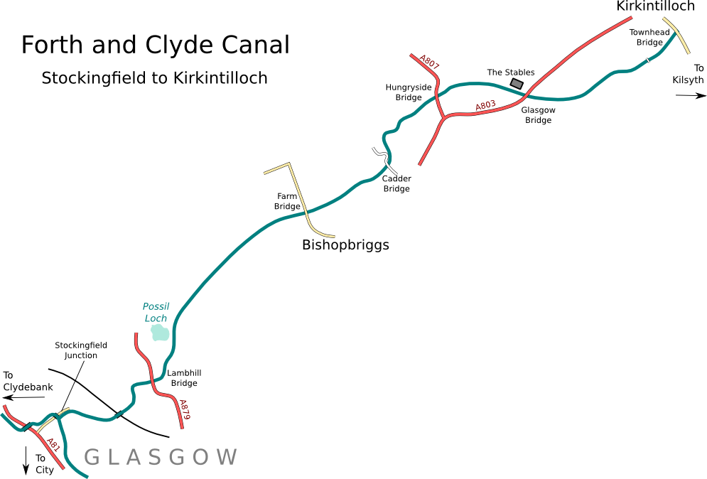
Map derived from data (c) OpenStreetMap
Heading east from Stockingfield, the canal changes in character and almost straight away feels more rural, although it's still within the suburbs of Glasgow for a while longer. The remains of an old rail bridge can be seen by the junction, and further on a working railway line tunnels underneath. The next bridge, at Lambhill, is a steel lifting bridge that no longer lifts now but is high enough for most boats to fit under. Just beyond the bridge is an original stables block, and the canal leaves the city behind as it passes the Possil Loch nature reserve.
A long featureless but pleasant enough stretch leads to Bishopbriggs. The bridge here was hated by early canal enthusiasts because it was the only low bridge on the eight mile section from Glasgow to Kirkintilloch and prevented larger boats from passing through. It was due to be raised by the Glasgow Canal Project but was left in place when the project ran into financial difficulties. It was finally rebuilt in the year 2000 for the Millennium Link; though the stone abutment of the old bridge can still be seen on the south side underneath the new concrete one.
The next bridge, Cadder, is in very pretty surroundings with nice trees and a picturesque old church. The canal cuts through the Antonine Wall here and rumour has it that the navvies even quarried a nearby Roman fort to get stone for the banks! A sharp contrast with the lengths the canals' restorers had to go to 200 years later to avoid disturbing the wall at Roughcastle when they built the new interchange. The River Kelvin can be seen to the north on the far side of several golf courses.
The trees end at Hungryside Bridge, another fixed steel lifting bridge, and the canal crosses open countryside to reach Glasgow Road Bridge carrying the A803. There is a good canalside pub in an old stables block, imaginatively named "The Stables". The bridge itself was once a restrictive Armco culvert (a corrugated metal tube through the road embankment), but was replaced by the current bridge by the Glasgow Canal Project in 1990, allowing the many boats based here to sail through to Kirkintilloch.
When the canal was completed, the inland town of Kirkintilloch effectively became a port on both the east and west coasts simultaneously! There was a lot of industry associated with the canal here, including boat building yards. Today there is a busy marina on the south bank, accessed by a stylish new footbridge. The main bridge in the centre of the town is Townhead Bridge. After the canal was closed this was culverted and became an eyesore right in the town centre, as weed and rubbish would collect on either side of the culvert. The construction of the new Townhead Bridge in the year 2000 was a welcome sight for the locals as well as canal enthusiasts. The stone abutments of the original Townhead Bridge, hidden inside the road embankment during the years of closure, are now visible under the new concrete deck.